Satellite-Based Analytics In Agricultural Insurance
Agricultural insurance is highly vulnerable due to climatic stresses that cause huge losses to farmers and force insurers into frequent claim payments. To remain solvent and increase their underwriting capacities, microinsurance companies are trying to partially shift their liabilities to reinsuring entities.
In their turn, reinsurers need to find out if the insurance case has really occurred. Of all possible techniques, remote sensing is the handiest one to shed the light on disputable issues by keeping a keen eye on them from space.
Overview: About Der Neue Horizont Re, S.A.
Based in Mexico with headquarters in Chihuahua, Der Neue Horizont Re, S.A. (DNHR) is a reinsurer of agricultural risks. By providing reinsurance services, Der Neue Horizont protects the insurance cases of their clients (aka cedents) in the agricultural sector and employs EOSDA Crop Monitoring to validate insurance claims.
The company is constantly improving its operation standards for the best quality of service, which has gained customer trust, and regularly passes the Fitch Ratings audits. In 2021, Der Neue Horizont Re, S.A. was issued ‘B’ and ‘BB (mex)’ Insurer Strength credit quality, confirming that DNHR met its financial commitments.
Der Neue Horizont is also a member of ALASA, the Latin American Association for the Development of Agricultural Insurance that aims to unite crop insurers and protect local farmers and ranchers in the Latin-American region.
Challenge: Extra Time And Resources To Process And Validate Insurance Claims
Der Neue Horizont handles insurance claims related to crop damage due to weather extremities like hail, wind, heat, or frost. Fitch Ratings classifies this niche as the “least favorable”. Indeed, it reports DNHR’s 169.6% combined loss ratio increase in the third quarter of 2021 due to the frosts that affected the Southern U.S. and Northern Mexican regions in February.
The cedents often report to the reinsurer on claims involving crop damage assessment, and the entire validation process would put additional strain. The DNHR’s clients are over 40 agricultural insurance funds covering 1,500 to 20,000 ha, which makes 5,000 to 6,000 ha per fund on average.
In the past, the company had to send out scouts to inspect the field and confirm the insurance case occurrence. Scouring through the fields to find the issue and affected areas lasted long and cost much, not to mention the long travel time to scattered, vast, and remote locations. After adopting remote sensing technologies on EOSDA Crop Monitoring, DNHR specialists can make their decisions easier and faster.
Fields monitoring platform, leveraging high-resolution satellite images to identify and react to any changes remotely!EOSDA Crop Monitoring
Solution: The Scouting Feature & Historical Data For Quick Damage Assessment
By tracking vegetation state on EOSDA Crop Monitoring remotely, Der Neue Horizont can understand if the damage has occurred and if it is necessary to inspect it with scouts, which saves costs. After damage detection, the scouts receive the task through the Scouting tool with pinpointed locations and problem description, which spares the trouble of scouring the entire field. Further, they take photos and send the report online or offline, regardless of internet connectivity in the field. Der Neue Horizont will get them once the scouts re-enter an Internet-available zone, which also saves the claim processing time.
Another step after damage detection or unhealthy crop development is to find out if the damage has occurred due to the reported factors or some other causes irrelevant to the claim coverage. In this case, EOSDA Crop Monitoring is helpful to analyze the whole crop production cycle in the specified fields and predict performance losses.
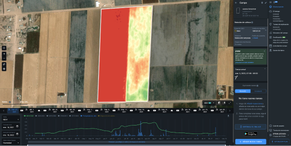
Most frequently, Der Neue Horizont uses EOSDA Crop Monitoring historical weather data and the sowing date. In particular, the company’s specialists analyze the NDVI and MSAVI indices which give a vivid picture of crop development through allocated colors, as well as precipitation, temperature, and soil moisture charts.
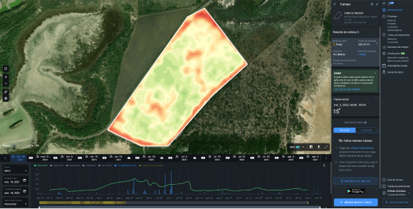
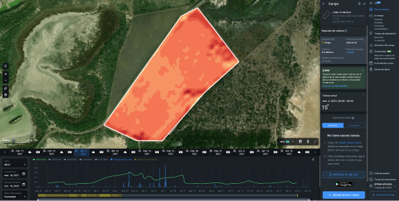
DNHR experts also track historical data to check if all agricultural activities were conducted properly to support healthy crop development and the overall field state. They analyze vegetation indices alongside other parameters throughout the whole season, not only during the land preparation for seeding but later as well, at different crop growth stages.
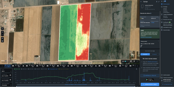
Besides, Der Neue Horizont customers sometimes recommend their clients to resow the field after weather extremities to mitigate losses. In this case, it is important for the insurers to control if farmers follow their recommendations and how efficient they are performing the task. DNHR makes the situation clear by using vegetation indices. In particular, the company’s specialists have monitored the field with NDVI.
Additionally, by figuring out the typical weather trends in the questioned area, EOSDA Crop Monitoring users can estimate crop insurance risks due to recurrent climatic threats in the area. It helps calculate insurance premiums more accurately.
Outcome: Save Resources And Validate Insurance Claims Faster, Yet With A Greater Precision
On EOSDA Crop Monitoring, Der Neue Horizont avails data-driven analytics to understand if the insurance case has occurred, if the field was handled properly, and if any insurance proceeds are to be indemnified. In particular, the EOSDA platform allows:
- assessing the current field state thanks to the satellite monitoring (regular data updating);
- spotting critical field areas faster and deciding on the necessity of additional farm scouting;
- tracking the crop development dynamics through interactive vegetation and moisture curves;
- checking meteorological conditions on weather charts.
As a result, Der Neue Horizont can efficiently allocate the scouting resources and resolve the disputable issues faster when an insurance claim report arrives. In this regard, the company finds the platform quite helpful. Furthermore, DNHR offers EOSDA Crop Monitoring as an added value to its clients, so everyone can have access to the fields in one place.
About the author:
Natalia Borotkanych has been working in the space sector for more than 15 years now. Her experience includes working in business, science, education, and government projects.
Natalia has a PhD in space history, Master’s Degree in Foreign Policy from the Diplomatic Academy of Ukraine, as well as Master’s Degree in Public Management and Administration from National Academy for Public Administration under the President of Ukraine.
Building upon her experience of working in the State Space Agency of Ukraine, Natalia now specializes in helping the state bodies and NGOs to implement the satellite monitoring technologies for solving real-world problems and for smart decision-making.
Natalia is an active science communicator. She is a scientific editor at The Universe. Space. Tech magazine. She also teaches a “Space diplomacy” course at the National Aviation University.
Natalia's experience in project coordination and scientific expertise in the space sector are much appreciated at EOS Data Analytics.
Recent articles
EOS Data Analytics Partners With Susanne Schödel GmbH
EOS Data Analytics and Susanne Schödel GmbH announce a strategic partnership to deliver AI-based satellite imagery analytics and improve crop monitoring and environmental conservation in DACH market.
Evapotranspiration Process And Methods Of Measuring
Evapotranspiration is the process of water vapor loss from the soil and plant surfaces. Farmers who are aware of the ET effects on crops are in a better position to increase their farm productivity.
EOSDA Aids Higher Crop Yields With Productivity Maps
Oleksandr Dzhevaga & Aleksey Kryvobok, EOS Data Analytics, discuss models for custom crop productivity mapping, developed as a result of in-house collaboration between data and soil scientists.